


Māngere was hit hard by major storms in 2023, causing flooding in pockets across the suburb, but particularly around the Te Ararata and Harania creeks in Māngere Central and Māngere East. Flood waters were at dangerous levels, with people needing rescuing and many whānau displaced in the aftermath
While most locals have moved on with their lives, the job continues to help affected homeowners and the community recover, while increasing their storm resilience and preparedness.
On this page:
- Category 3 progress
- Flood resilience projects
- Stormwater maintenance
- Flood risk categories
- Wellbeing support
- Removal of high-risk homes
- Maintenance of Category 3 properties
- Unit title and cross-lease situations
- Future use of storm-affected land
- Community recovery planning
- Flood awareness and preparedness - what you can do
- Flood maps
- Managing development in hazard areas
Category 3 progress: 26 March 2026
|
|
Category 3 properties |
Buy-outs settled |
Houses removed |
|
Māngere central |
37 | 23 | 6 |
|
Māngere Bridge |
2 | 1 | 0 |
|
Māngere east |
6 | 4 | 1 |
|
Favona |
2 | 1 | 0 |
|
Total |
47 | 29 | 7 |
We have begun removing Category 3 homes now in council ownership, so far completing seven removals to help move recovery forward for the community. These are homes where the risk can’t be reasonably mitigated, and whānau accepted a buy-out offer to move out of harm's way. A small number are still working toward finalising their buy-out. Future use decisions for these properties will take time.
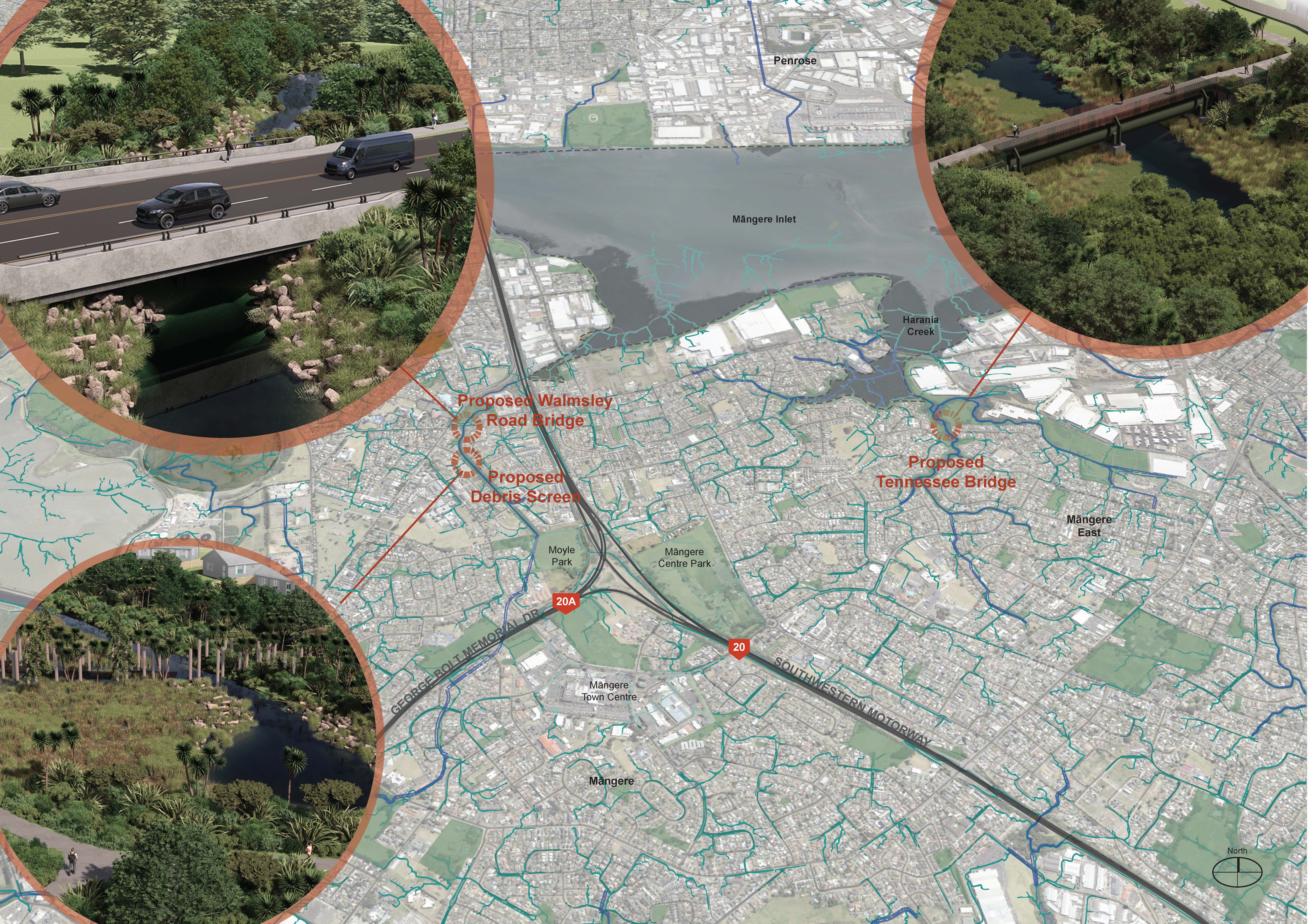
Major flood resilience projects
These two highly impacted areas are the first in Auckland to be prioritised for major $53 million flood resilience projects.
Projects underway around the Harania and Te Ararata waterways will reduce flood risk for hundreds of homes.
In Māngere East, one of the largest cranes of its kind in New Zealand has lifted a new section of a major wastewater pipe into place as part of the Hārania Creek flood resilience project. When finished, the project will allow floodwaters to flow freely into the Manukau Harbour. In Māngere central, the Walmsley Road bridge - where Te Ararata Creek flood resilience works are underway - will soon reopen, with the full project complete in August. Together, these will reduce flood risk for up to 1,000 homes, including 31 Category 2C properties identified as having a serious risk to life.
A Stakeholder Advisory Group for the projects, made up of Māngere community members, is helping provide feedback while taking information back to the community.
Visit the Auckland Council website to find out more about each of the Te Ararata and Harania flood resilience projects and any traffic or local impacts. You can also email the team at bluegreen@aucklandcouncil.govt.nz with specific questions.
Ongoing stormwater work
To increase storm resilience the council has also:
- removed tonnes of debris from local streams and waterways including the Mahunga culvert
- increased inspections and maintenance of key pipes and streams
- increased catchpit cleaning from once to twice per year
- installed hotspot cameras to identify blockages for faster removal by Operations teams
- upgrading to ‘back-entry’ catchpits that still take in water if the top grate is blocked.
Alongside this we are working with the community to help reduce dumping around streams and increase storm preparedness. In Māngere we have partnered with the Te Ararata Stream team (Te Ararata Stream) and BlueSpur consulting (Māngere inlet and Harania catchment) to improve local flood knowledge, expand stream restoration efforts, and support stormwater management. Get in touch with these groups or keep an eye out for local events!
Flood risk categories at storm-impacted homes
The council has been assessing homes affected in the 2023 storms that registered for a future risk category, offering buy-out or construction grant support depending on the risk.
Visit our Tāmaki Makaurau Recovery Office website for more information, or these pages on the council website for detailed information about each category:
- Category 1: 79 homes in Māngere were cleared of having an 'intolerable risk to life' from future flooding and landslides.
- Category 2C: 31 homes in Māngere were identified as having an ‘intolerable risk to life’, but local flood reduction projects underway will reasonably reduce the risk.
- Category 2P: 3 homes in Māngere were identified as having an 'intolerable risk to life', but are receiving support to implement solutions at their home that will reduce this risk to a reasonable level.
- Category 3: 48 homes in Māngere were identified as having an 'intolerable risk to life', but there is no viable solution to reduce the risk to a reasonable level. These homeowners have been offered a buy-out to help them move out of harm's way.
For information about storm affected Kāinga Ora properties in the area, email EngageMangere@kaingaora.govt.nz
Wellbeing support
Various community and wellbeing support is available for storm-affected residents, including free help with processing home insurance claims, rates relief, temporary accommodation assistance, and wider financial and mental health support. Check out the available wellbeing resources on OurAuckland.
The Storm Recovery Navigation Service closed as of December 2025, as many of the whānau affected by the 2023 severe weather events have moved forward in their recovery journey.
Removal of high-risk homes
Around 1200 homes across Auckland have been assessed as Category 3 (intolerable risk to life) and are being offered a council buy-out to help them move out of harm’s way.
In Māngere there are 48 homes in this position. We still have a number of Category 3 homeowners going through the buy-out process in Māngere, and are yet to lock in specific removal plans.
Once owned by the council, high-risk Category 3 homes will be removed in clusters as part of our home removal programme (and we’ll continue to look at how we make Category 3 units within multi-unit complexes safe). Most homes will be relocated or deconstructed, with around a third relocated for use elsewhere. Salvageable materials will be sent to recycling partners for reuse.
As we confirm detailed plans for the rest, we’ll inform direct neighbours and previous homeowners, while keeping the wider community updated about the general programme of work. Please contact RecoveryOffice@aucklandcouncil.govt.nz if you require more information.
Read more on the home removal programme page.
Maintenance of Category 3 properties
After settlement of a property, Auckland Council provides a basic level of maintenance on a monthly schedule. The focus is on maintaining areas visible from roads and footpaths i.e. berms and front yards on properties that have road frontages. Regular security patrols will also monitor the properties.
If you have an issue with a Category 3 home that has been purchased by the council, please raise a maintenance request in the ‘Auckland Council Report a Problem tool’ under the 'Community venues, parks, beaches and public spaces' heading. Note that until council takes ownership of a property, we are unable to do any work on it.
Damage from break-ins and vandalism is an ongoing issue, with more and more houses having to be boarded up to prevent this. If you see any suspicious behaviour please report it to the police.
For questions about maintenance/security of storm-affected homes check out the FAQs.
Future use of storm-affected land
With around 1200 high-risk Auckland properties expected to be purchased by Auckland Council as part of the recovery from the 2023 extreme weather events, it will be one of the largest land acquisition programmes undertaken in New Zealand.
We are carefully deciding what to do with this storm-affected land, with decisions expected to take years - we do not expect to confirm many in 2026.
A region-wide policy guides what we do with this land. Our top priority is always safety, but we also need to make sure we’re delivering good value for Aucklanders, especially given how expensive these buy-outs have been. You can find the policy online at ourauckland.nz/futureuse.
Essential use or hazard management
We're considering how Category 3 land can support essential council services like flood mitigation, which will save Aucklanders money in the long run. We expect around half of the properties to remain with council either because they're useful or need management due to high hazard risks.
Interim uses
In the meantime, we’re considering safe temporary uses with supporting guidelines. Community groups and organisations can apply to use this land for low-risk, non-residential activities like planting, grazing, play equipment, or temporary events. Guidelines are available at ourauckland.nz/futureuse.
Got a land use suggestion?
After looking at the guidelines you can make suggestions for future or interim uses at ourauckland.nz/futureuse. We’ll only get in touch when we have an update – this will take time.
Category 3 neighbours
While decisions for the future of all 1200 Category 3 sites will take some time, we know this uncertainty can be difficult for neighbours, and particularly for shared ownership neighbours.
Where Category 3 properties are part of a cross-lease or unit title, council will work with shared owners to resolve its involvement, with each site handled individually. Given the number of properties in this complex situation, it will take time to get to, and work through, each.
We will continue keeping neighbours informed on the removal of storm-affected homes, including seeking any written consent that may be required from cross-lease owners.
Where neighbours or community members have permanent use suggestions for specific Category 3 sites, we can capture that information in our future land use expressions of interest register below.
Guides for Category 3 neighbours
More information is available in our guides for Category 3 neighbours:
- Home Removal Guide For Neighbours (2.7MB PDF)
- Guide for cross lease and unit title neighbours of Category 3 properties (4MB PDF)
Looking forward: Community recovery planning
We know that there will be a lot of change in these areas – with families leaving, homes being removed, and major flood resilience projects under construction.
Community-led recovery planning is now underway for Māngere, helping locals work together to navigate this time of change and actively address their needs at the street, neighbourhood or community level. With approximately $300,000 in recovery funding available for recovery initiatives and projects, the focus has been to help as many people as possible have a say.
The Māngere Community Recovery Leadership Rōpū - made up of affected residents, faith leaders, and representatives of local organisations - continues to work hard on turning community recovery needs into action. Four main priorities have emerged from listening to locals over the past year: social connection and community wellbeing, education and advocacy, readiness and resilience, and building community leadership capability. The Rōpū is now considering how locals will help turn these into real initiatives with dedicated recovery funding.
Preparing your home and family
There is a lot of information available about flood risk in communities and at homes, with a key resource being the Auckland Council Flood Viewer where you can search to find Auckland addresses. Connected to this, there is some fantastic information, including language translations, to help you reduce the flood risk at your home and keep your family prepared.
Reporting flooding, dumping and stormwater blockage issues to 09 301 01 01 will ensure the council can address issues as soon as possible.
Emergency readiness
An Emergency Readiness Plan is now in place for the Māngere-Ōtāhuhu Local Board area based on its unique geographical, social and hazard profile. The plan identifies the local board area’s top hazards and provides tips on reducing risk, preparing for emergencies, and navigating the recovery process. In the meantime, Auckland Emergency Management is working with local partners to support local preparedness activities.
You can find this emergency readiness plan on the Auckland Emergency Management website, including a handy summary guide. These summary information sheets are being translated into Samoan, Tongan, Hindi, Chinese, Te Reo Maori and Korean.
The new One Love: Ready Neighbourhoods initiative, supported by Auckland Emergency Management, is helping neighbours get to know each other and build the kind of street-level bonds that make all the difference when the next emergency hits. Sign up here to join and receive monthly newsletter updates, or become a champion for your street.
If there are any community groups who would like to support their communities during and after a disaster, to get in touch with AEM on aeminfo@aucklandcouncil.govt.nz
Understanding Auckland's flood maps
In Auckland, we’ve seen how natural hazards like flooding, coastal erosion and landslides can impact people, homes and businesses.
We’re also seeing more Aucklanders interested in knowing about their flood risk including when they’re looking to purchase property or move into a new rental property. This includes checking the flood hazard maps on Auckland Council’s Flood Viewer or Geomaps beforehand, or by purchasing a Land Information Memorandum (LIM) report.
Visit our flood maps explainer for some useful information on how and why we publish these maps, and what they mean.
Managing development in hazard areas
Auckland Council wants to allow more housing choice - but in the right places. Since 2023 floods Auckland Council has been advocating to the Government for the power to be able to strengthen planning rules even further
Stronger planning rules for Auckland hazard areas came into force on 3 November 2025. These are key elements of Plan Change 120 which seek to restrict building in high hazard areas and strengthen the standards that must be met by developers when applying to build in these areas.
There are maps showing zones that determine what kind of development will be allowed where – to ensure building happens in the right places. However, regardless of what planning zone a property is in, strict consenting rules will apply for any development being proposed in a hazard area. They will have to show the risk can be mitigated and not impact neighbours etc.